Wednesday, Oct. 8th - Monday, Oct. 13th
We left Helena Wednesday morning and drove to Payson, Utah on I-15 where we had supper at a little Chinese place and spent the night in an empty parking lot across from Walmart. The next day we drove to St. George, Utah where we had an appointment at Freight Liner to get our oil gauge fixed. They had to order a part, so we camped in their lot until the part came in on Monday.

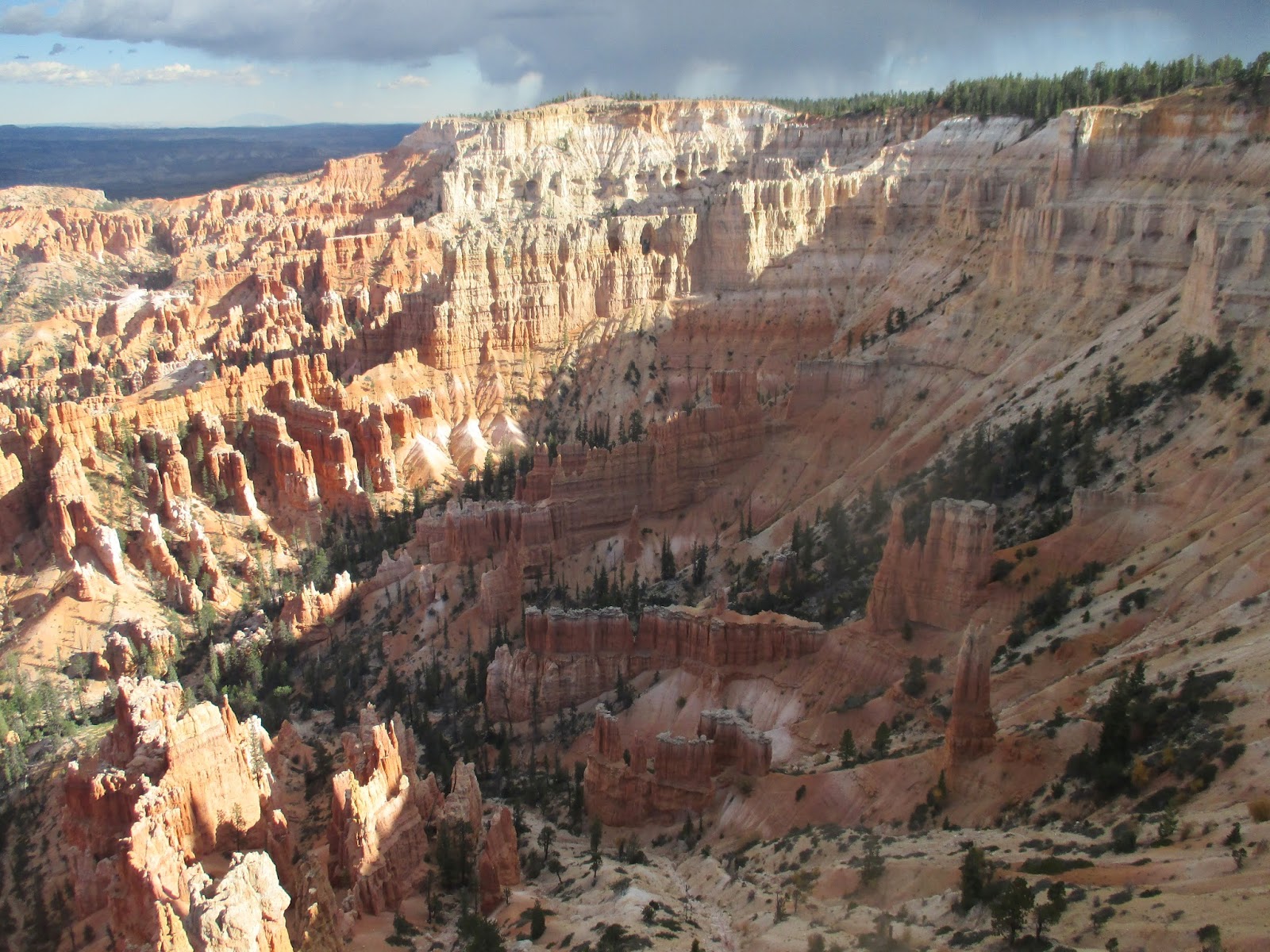
Friday we drove over to Bryce Canyon National Park and spent the day exploring and hiking around a bit.

This is Bryce Amphitheater.

There are lots of hiking trails down into the maze-like landscape,

with lots of people hiking all over, way down in the canyon as far as we could see looking like little ants.

Rainbow Point, elevation 9,115 feet.

Agua Canyon, elevation 8,800 feet.

Natural Bridge is misnamed because it was not carved by a rushing stream and is actually just an arch caused by other erosion.

This lone yellow Aspen tree caught my eye as we were parking. Then I saw a guy with a big camera on a tripod taking pictures of it. I wonder if his turned out better than mine.

Piracy Point.

A little closer view. Some of these formations look as if someone has poured a layer of cement on their tops.

View from Inspiration Point, elevation 8,100 feet.

From there I walked the Rim Trail 1.3 miles up along the trees over to Bryce Point.

John walked a short way up the trail and then went back and got the car and drove over to pick me up.
View down into the canyon along the trail.
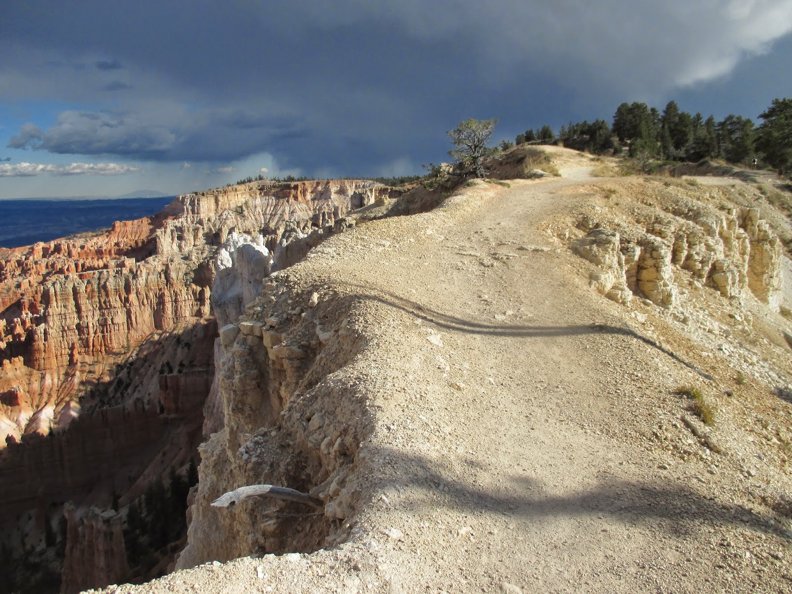
Part of the Rim Trail. It wasn't all right on the edge like this, but this part did remind me of when I rode the mules down the trail into the Grand Canyon. That was a little spooky until I got used to the idea that the mules were very sure-footed and knew what they were doing. The views along the edge are incredible, if it doesn't bother you to be there!

Another arch along the trail.

Driving back to St.George that evening and over to the Grand Canyon North Rim the next day, the Quaking Aspen trees were sparking in the sunlight.

The breeze blows their little leaves around and the sun shining on them just makes them shimmer like like sequins on a dress. Their stark white trunks almost glow in the sunlight. The radio was playing Wynn Stewart's "It's Such a Pretty World Today". Perfect!

They were really beautiful and I can only imagine how much better they must have been a week or two earlier. As you can see, about half of them had already lost all of their leaves.

One of the first campers we saw as we entered the Grand Canyon National Park. It was so cute, all hand-painted.

It was $25 per vehicle for a 1 to 7 day pass, but when you are 62 you can buy a lifetime pass for $10 that gets you and everyone in your vehicle into all the national parks in the country. We use our pass a lot.

This is the nice paved path from the old lodge out to Bright Angel Point.

Check out the two guys in this picture. The one way in the distance climbed up on top of the rocks at the end of Bright Angel Point.

View back toward the lodge which you can see a little bit of way up in the right hand corner.

Another view.

Walking back toward the lodge.

Check out the guy sitting out on the end of the white colored rock point near the center of the picture,

View point right below the lodge. From here it is about 10 miles straight across to the lodge on the South Rim where I did the two-day mule ride down into the Grand Canyon a few years ago with some girl friends, while John hiked it. It is a 215 mile, 5 hour drive by car. Congress established the Grand Canyon Park in 1919, but miners brought burros here long before that and eventually abandoned them here. The first tourist lodge "Wylie Way" opened in 1917 on the North Rim operated by Wylie's daughter and son-in-law. Their son, Bobby, befriended an abandoned burro named Brighty. They worked together hauling water from a spring about a half mile below the rim. Each day Brighty's pay was a stack of flapjack pancakes. He allowed boys and girls to ride on his back.

This is a statue of Brighty in the lodge. John remembers reading the book "Brighty of the Grand Canyon" by Margerite Henry as a kid. Maybe we can find it in the library and read it to our grandkids.

We stopped for a little picnic and a glass of wine with a view. No, that's not peanut butter in the Skippy jar.

A little Siberian Aster.

A closer view. We saw lots of these when we were in Alaska.

Cliffrose.

Indian Paintbrush.

Not sure what this delicate, little flower is. Looks like little red stars.

Angel's Window in Kaibab limestone.

Near the center of the picture you can see the winding Colorado River.

View of Wotan's Throne from Cape Royal Point. The North Rim is a maze of jutting rock islands and side canyons with many formations that look like temples and castles. The North Rim has eroded more than 7 miles from the river's edge, while the South Rim has only eroded 3 miles. The North Rim is higher than the South Rim by 1,200 feet and captures twice the amount of rain and snow.

I was watching this guy and I could just tell that he was thinking about climbing down onto that next shelf and getting closer out to the edge. He stood there contemplating for several minutes and finally turned around and walked away.

Check out this guy,s t-shirt. It's a target and says "God bless our troops....especially our snipers". I'm just not quite sure what to think about that.

Hiking the Roosevelt Trail.

Point Imperial, elevation 8,803 feet, is the highest viewpoint in the park, 7 miles from the Colorado and more than a mile above it, also the deepest view.

Closer view.

Sunday we drove out to see the grave sites and monuments where the Mountain Meadows Massacre took place during the so-called Utah War in 1857. There was a wagon train with a group of settlers from Arkansas bound for California. On September 7th a group of local Mormon settlers and Indians attacked the wagon train. They were joined by a contingent of territorial militia consisting of Mormons acting on orders from local religious leaders and military commanders. They laid siege to the wagon train for five days, during which time they killed 15 men. Then they persuaded the emigrants to give up their weapons and leave the corralled wagons in exchange for a promise of safe passage. When they were all out and some were more than a mile up the valley, they suddenly attacked them and killed more than 120 men, women and children. Only 17 children under the age of 6 were spared and eventually returned to relatives in Arkansas. In 1859 there was a memorial put up and the graves were preserved and protected by local families and ranchers until 1999 when new monuments were put up by the Mountain Meadows Association and the Church of Jesus Christ of Latter Day Saints. It is now a National Historic Landmark.

There is a monument with all their names engraved on it on a small hill about a mile above the main grave site. They were buried in group graves spread out in the valley for a mile or two wherever they were killed or the bones were found. There are four or five of these markers you can drive to around the valley.

When we left there we drove over to do the Kolob Canyon scenic drive in Zion National Park.

When we got to the end of the drive there was a hiking trail and John said I could hike it if I wanted and he'd just wait in the car, so off I went. This section of the trail had one foot gaps every ten feet or so to let the water run through and not wash out the trail.

It turned out to be longer than I thought, about a mile and a half.

And it got quite rugged toward the end, especially considering I just had floppy sandals on.

But I made it.

And the view was great! When I got back to the car, he said, "I didn't think you would really go." Well!
Monday our part came in and we were on our way to Havasu City where we will stay for a few days before heading down to Yuma.
Tarra
