Mon, July 16th - Wed, July 18th in Anchorage, Thur, July 26th - Sun, July, 29th in Seward & back in Anchorage Wed, Aug. 1st - Fri, Aug. 3rd
 Have you seen these? They look like something I would like. Our first day in Anchorage we walked about four miles on the 11 mile Tony Knowles Coastal Trail along Knik Arm, off Cook Inlet, to Earthquake Park. Then we walked back through the city another 4 or 5 miles. There are 10,000 acres of parks and over 120 miles of trails in the city.
 Just a picture of a guy taking a picture of the city skyline. Earthquake park is where a big residential section of the city slid into the ocean during the 1964 earthquake on Good Friday. It was a 9.2 earthquake, the largest earthquake in North America and the second largest ever. It lasted almost five minutes, compared to the L.A. quake that lasted only 15 seconds. It was followed by 11 aftershocks over 6.0 in the first 24 hours. 115 people were killed, many washed away by the tsunamis that followed.
 A little further down the trail, we met some folks who told us there was a moose around the corner. What they failed to notice was her calf laying in the grass to the right. They have about 150 each, moose and bear in the city. There are 155,000 to 165,000 moose in Alaska. They live 15 to 20 years and yield about 500 pounds of meat. Only the males have antlers which they lose each year in Jan. or Feb. They start growing them again in May or June for about four months, growing up to an inch per day. They get bigger each year and enhance their hearing, which is only surpassed by their sense of smell.
  President Eisenhower signed into law the act admitting Alaska to the Union as the 49th state on January 3, 1959. Directly behind the monument is the railroad station and behind that are the shipping docks. Downtown is right behind us, where they have heated sidewalks and covered walkways between some of the big buildings like the Performing Arts Center and shopping mall.
 Our campground is just a couple blocks away. We spent one day at the museum and one day at the Alaska Public Lands and Information Center, with five movies, exhibits and a guided ranger walk around historical downtown. Both were very good.
 We also stopped by for the free "tour" of the Ulu Factory, which turned out to be no more than a look through the windows to see the knives and cutting boards being made and a little TV clip to watch. Ulu knives are the type of knife the natives have used for centuries to fillet their fish. They are supposed to be great for chopping all kinds of stuff.
 There were lots of food venders on the downtown streets, but this one had a constant line of folks waiting for three hours over lunch, while there were very few at the others. The reindeer sausage dogs must be really good, to wait so long in line and put up with this abuse, but I suppose it does keep the line moving.
 It's not every day you see a stop sign that says to yield to aircraft. The number of small planes up here is astounding. They have 800 float planes taking off daily from one of the lakes in town.
 This is a view from Point Woronzof on our way out of town, with a view back toward downtown. Point Woronzof is between the two arms off Cook Inlet, Knik Arm and Turnagain Arm. Captain Cook originally went up Knik Arm looking for the elusive Northwest Passage. He was forced to turn around when he found no passage. Then he went up the other arm looking for a passage and was forced to turn around again when no passage was found, thus the name Turnagain Arm. Turnagain Arm has some of the most dangerous tides in the world. They go out over thirty miles and come barreling back in raising the tide over 28 feet in six hours. The mud flats look inviting to walk out on when the tide is out. However, if you stand still, your feet will sink into the mud like quick sand and you will be unable to pull them out. You will be trapped there watching the tide come back in. The fire department makes several rescues each year with a portable generator to spray powerful jets of water down around the legs to pull them out and then run for it, before they start sinking in.
 Another little bit of Alaskan humor. This was on the side of a little bar in Soldotna. It said, "WE I.D. THIS ONE'S BARLEY LEGAL". Another sign we saw at the Darwin Theory Pub in Anchorage showed a monkey holding a sign that said, "Tourist Trap, mingle with URBAN WILDLIFE, visit heavy petting zoo in back room." I think they must have too much time on their hands during those long dark winters up here.
 Leaving Homer, we stopped at Anchor Point, North America's most westerly highway point. These big tractors back the boats into the water here at a charge of $65.00.
 It must be because of the soft sand that you can sink into, because it didn't appear to be very steep. But a guy told us that it's totally worth it, because the fishing is so good.
 Then we took advice from the Milepost and took a side road about nine miles out to the little Russian town of Nikolaevsk for lunch. It was quite an experience, as you can probably guess from the picture. The crazy Russian lady, Nina, who serves lunch out of her little home insists on dressing you up and taking your picture. The meal was borsht (beet soup), pirougees (bread filled with mashed potatoes or cabbage), heavenly sauer Kraut (not the least bit sour, with lots of other veggies in it and a tomato base) and the best ever sausage. Plus a cream puff for dessert and incredible tea, even John liked it, and he hates tea. If this all sounds good to you, it was, but bring lots of cash, and consider a good portion of it a donation to needy children in Russia. She says she sends a good portion of her profits to them. All I can say is, with her on their side, they shouldn't be needy much longer, but good for her. The worst part was that John wanted to stop and get more to eat, because he was still hungry.
 Just a little yard decor in Seward. Seward is Mile 0 of the original historic Iditarod trail to Nome.
  We camped at the city campground right on the beach in Seward. This was our view.
  I was up late one night working on my blog. This cruise ship was pulling in just as I was getting ready for bed at 3:00 A.M. It was beautiful, like a floating casino or hotel, which I guess it was.
 The same cruise ship in port the next day and the Seward Small Boat Harbor.
  The river across the road from our campground.
  Another view of the river.
  View of our campground as we head out on a cruise. As the captain on our cruise pointed out, all of the downtown area that was here during the Good Friday Earthquake of 1964 was wiped out. So they turned it into parking lots and campgrounds. I guess if the tourists get washed away, no problem.
 Our cruise took us way out to the end of Resurrection Bay into the ocean and to the Chiswell Islands where there are scientific observations of wildlife taking place by camera, tagging and other remote devices.
 We saw several pods of orcas (killer whales). They are not actually whales, but members of the Dall porpoise family.
 We also saw some humpback whales in the distance, but I didn't get any pictures of them. They are endangered and Alaska is home to over half of the world's population of humpbacks.
 They called this guy Lobster because of his deformed dorsal fin.
 Approaching a sea lion rookery, or breeding place, in the Chiswell Islands, one of the most studied rookeries in the world. Since the 1970s the numbers of sea lions and seals have decreased in this area by nearly 80%. Seals can dive more than 600 feet deep and stay down for a half hour. They can even sleep under water.
 A close up, so you can see the big males, the moms and the pups.
 And a little closer look yet at the Steller Sea Lions which can grow up to 13 feet long and weigh over 2,000 pounds. The Harbor Seals only weigh about 250 pounds.
 We have passed Holgate Glacier and Pederson Glacier and now we are approaching Aialik Glacier, the largest tidewater glacier in the Kenai Fjords National Park and the most visited. It is part of the Harding Ice Field, which feeds nearly forty glaciers, most of which have retreated in the last 100 years, some as much as nine miles. Approximately fifteen feet of snow fall on the icefield each year. It's massive size was only discovered in the early 1900s, fifty miles long by thirty miles wide.
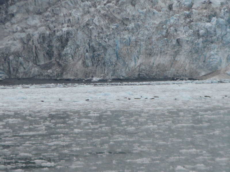 Getting closer, we can see something floating in the ice.
 Moving in, we see these cute little sea otters just floating around and playing in the ice. Sea otter fur is the thickest of any animal in the world. They were the reason the Russians came here and they almost killed them all off. Then they sold us Alaska for $7.2 million in 1867, a transaction that was called Seward's Folly for Lincoln's Secretary who arranged the sale. When asked what his legacy would be, he said the acquisition of Alaska, but it would take a century to prove it. How right he was... gold, copper, oil, timber, jade, seafood, etc.
 They really are so cute. They are the smallest of the marine animals and don't have blubber like other marine animals. So they have to constantly fluff their fur to incorporate air into their coats, to create an insulating layer of warm air. They spend most of their time eating and grooming afloat on their backs.
 And these guys aren't so cute, but for a Granny and Gramps, they're not so bad, I guess.
 We did get to see the glacier calve a half dozen times or so, and hear it! It creaks and groans and cracks and sometimes there is a loud noise like a shotgun blast from the back side somewhere. Big columns of ice break away and come crashing down into the water with a loud crashing sound and create big waves. It doesn't look very big in the picture, but we are about a half mile away.
 Even Santa Claus needs a break once in a while. This is the bridge over Sheppler Creek next to our campground.
 Another bunch of guys very happy with the results of their fishing trip. I think the biggest one here was 149 pounds. I wish I could have a couple of those for my freezer. The cost of the charter, plus the cleaning, vacuum packing, freezing and shipping adds up to some serious $$$$.
 This is our first view of Exit Glacier just a few miles outside of Seward, also in Kenai Fjords National Park and part of the Harding Ice Field.
 I was here sixteen years ago and the glacier was right up to my feet, where I am standing to take this picture. I was astounded by how much it has receded. The park ranger told us that they have been concerned about global warming long before the general public, because they see first-hand how fast the glaciers are receding closer to the artic and anarctic regions and all the higher elevations across the world. At peak, ice covered 30% of the earth and today only covers 10%.
 These cars are two of the styles the parks are now using to limit the effects man is having on the earth. They are using all kinds of solar and fuel efficient stuff in the visitor centers. The Gem goes 25 mph and gets 40 miles per charge. It takes 5 kwtt for a charge and creates 5 pounds of CO2 emissions in 40 miles. The Subaru Outback creates 40 pounds of emissions in 40 miles.
Just me again. You don't get a picture of the picture taker very often.
 On our way north, we stayed at the Williwaw Campground again on Mon, July 30th. We visited the Begich Bogg Visitor Center which was named in honor of the two Congressmen, one from Alaska and the Speaker of the House, whose plane went down back in the 70s, along with the pilot and one aide. The search went on for over a month, but they were never found. From here we went through the tunnel over to Whittier. It is a one-lane tunnel two and a half miles long shared by the train and vehicles. It was just a railroad tunnel until 2000 when they converted it to be shared with vehicles and created the first road into Whittier. It was an $80 million redesign and the first computerized regulation of both rail and highway traffic. The tunnel was built during WWII when Whittier was considered a vital port, railhead and supply line for Alaskan security.
As we left the tunnel, the first thing we saw was their airport. I had read somewhere, that if you were flying into Whittier, you should be aware that the airport is very short with the bay on one end and the highway on the other. Wow, looks like a very tight landing! We camped overnight in Whittier on Tuesday, July 31st.
 This was the view right outside our camper. Whittier is at the head of Passage Canal on Prince William Sound. They did have an interesting little museum about some of their local legends who fought in the Aleutians during WWII, after Japan attacked Dutch Harbor and took over the islands of Attu and Kiska. The three week battle to retake Attu was one of the bloodiest battles in the Pacific. There was also a small section about the building of the Anton Anderson Railroad Tunnel that is now shared with cars.
 The population is 159. There's not much here besides a port for shipping and a marina for fishing boats. We did eat at a little seaside joint. The kid cleaning up out front said, "Come on in. It's the only five star cuisine in Whittier." So how could we resist? We had excellent halibut and chips, as we sat on the patio and enjoyed the view of the marina. I don't know if you can read it or not, but the name on one of the boats here was E-fishn-C, clever. A few other cute names were Exhausted, TookALook and Bar-Tender.
 Almost everyone in town lives in this highrise that was built in the 1960s. Inside on the main floor is the post office, a small store, a room with vending machines, a small town office and a lounge. I went in to mail a post card and felt just like I was back in a college dorm in the late 60s, early 70s. It was originally called the Hodge Building after a Colonel in charge of building the Alcan Highway, who was lost in a flight over Oregon. His plane was found four months later. It is now called Begich Towers after the Senator killed in the plane crash in the 70s and never found.
 This interesting little pedestrian tunnel goes under the train tracks over to the dockside area and the few businesses there. We walked through several times. Each time we walked through this bike was in the tunnel, but in a different place, so we decided it must be a community game. So John moved it and sure enough, when we came back through, it was moved again. Those Alaskans will do anything for entertainment! The day we spent here was gorgeous, sunshining and close to 70. We were very lucky, because I think rain is more the norm for them.
 As we were leaving town the next morning, this is a view of the Buckner Building abandoned by the Army after the 50s. Named after General Buckner who was in charge of 300 military installments and 150,00 civilians in Alaska during WWII. He was one of the senior commanders at the Battle of Attu and organized the 10th Army for the Battle of Okinawa, the largest sea/land/air battle in history. He was killed by shrapnel to the chest four days before the end of the battle. He was the highest ranking officer killed in the Pacific Theater and the son of a famous Confederate General. It was originally built to house all the troops they brought here during WWII. It was at one time the largest building in Alaska and housed over 1,000 troops. It was built in seven sections with eight inch gaps between to withstand earthquakes and did survive the big 1964 earthquake.
 Heading toward the tunnel to line up and wait our turn to go back through. It is all computerized. You just pull up in the appropriate line... car, RV, bus, truck, etc. and watch the reader board that will tell you what time you will be allowed to proceed. The cars come to Whittier on the hour and leave on the half hour and have fifteen minutes to get through the tunnel at a speed of 25 mph.
  Trains presumably go through during the other times. If their timing is off, the reader board will tell you that there is a train and you need to wait until the train has cleared the tracks. Well, duh! I'd like to think most of us could figure that one out, but John says, "Never take anything for granted." I guess that's why he's the captain and I'm only the co-pilot.
  Well, the train is gone and now it's our turn to proceed. There are several turnouts (safe houses) along the two and a half mile tunnel in case of emergency, but you are not supposed to stop for any reason. It's all about the timing.
  Back in Anchorage for two days, we just walked around town a little, nothing special. This made me think of the movie, "The Long, Long Trailer" with Lucille Ball and Desi Arnez. It's hilarious!
  Just a few flowers in the Downtown Square Park. The flowers here are just amazing. There are flower beds and hanging baskets everywhere.
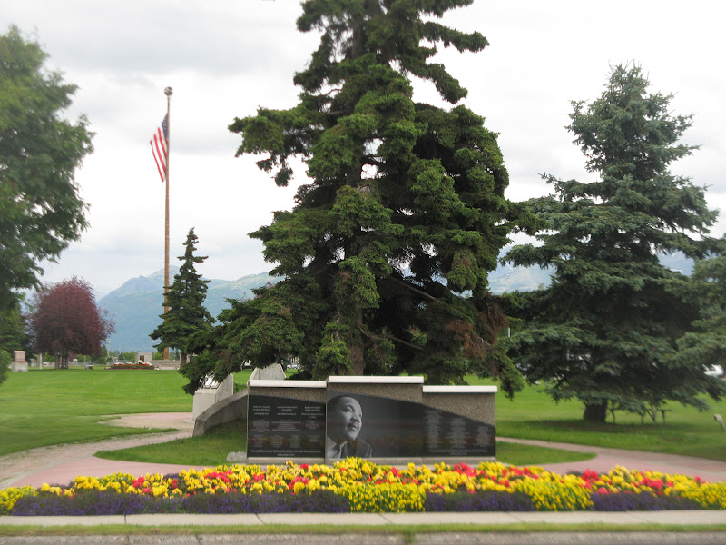 Delaney park is a strip of land down the center of town originally set aside as a fire break, to keep any fires from spreading and burning down the whole town. However, pilots found it to be a great place to land and used it as an airstrip. Now it is just a wonderful park that runs about fourteen blocks long. This block had a monument to Martin Luther King, Jr. on one end and a Veteran's Memorial on the other end.
 It was our "Jack Benny" anniversary on Aug. 3rd. For you youngsters, that's the 39th. So we went out to this nice place on Ship Creek for a special seafood buffet. The port was originally called Ship Creek Anchorage and was later changed to just Anchorage. Lots of folks fishing down along the creek here, too.
Heading toward Valdez on Friday, Aug. 3rd.
Smooth sailing to all,
Tarra

No comments:
Post a Comment