 Tue, Aug. 21st - Sat,Aug.25th The native village of Gitanyow has one of the largest concentrations of standing totem poles in northwestern B.C. The Gitanyow/Kitwancool Historic Village & Interpretive Center is here. It was closed when we stopped, but when it is open you can get a guided tour.
  These monuments in cedar proclaim the owner's clan status and inherited family traditions, but were never associated with religion. They are a unique primitive art form. The closest one here has an opening cut in it. I'm sure it has some special signifigance, other than sticking your face in it for a picture, but maybe not, as there is a ladder behind it to climb up to it.
  I never knew that totem poles were hollow and open on the back side. Some of the totems are unfinished and that means the person they belonged to has died. Someone will carve their family crest animal on top, otherwise it is left unfinished. The family clan you belong to is your mother's family.
  Just a few miles away is the Kitwanga Fort National Historic Site where a native tribe once had a wooden fortress atop Battle Hill from the late 1700s to early 1800s. Their chief was famous for battles attacking other tribes and fending off their counter attacks from his hilltop retreat. He was finally killed in a battle in the 1830s and the fighting ended and the fort was abandoned. Some of the totem poles tell the stories of his famous escapades. I guess he was kind of their Crazy Horse or Geronimo.
  We hiked down the stairs, around the back of the hill and up the stairs to the top of the hill, reading their story along the way. The First Nations people traveled a vast network of trails and canoe routes to trade. This photo is from the top of Battle Hill showing the stairway back up to our camper.
  The Kitwankul Grease Trail, a 60 kilometer trail between the Skeena and Nass Rivers, passed near Battle Hill. They rendered the grease from the Eulachon (candlefish) fish, which was highly valued, and carried it all over to trade with other tribes. They were believed to travel as far as the Bering Sea.
  St. Paul's Anglican (Episcopal) Church in nearby Gitwangak. The bell tower standing beside the church houses the original bell from the 1893 bell tower. There is also a fine collection of totem poles in this village and at nearby Kitseguecla and Kitimat and at Kispiox, north of The Hazeltons (Totem Pole Capitol of the World).
  The Hazeltons (Old, New and South) have a very nice Visitor Center with statues of a miner, a logger and Cataline, the best Packer in B.C and possibly North America. He played a major part in opening the Interior with his long mule supply trains carrying freight. He is one of B.C.'s greatest frontiersman and is buried high on a ledge overlooking Old Hazelton and the Skeena River.
  We hiked along the Skeena River in Old Hazelton and checked out their little museum in the city library. Old Hazelton was the upriver terminus for sternwheelers from 1886 to 1913. It is the oldest surviving pioneer community in northwest B.C. and was established as a post for the Hudson's Bay Company.
  There's a boardwalk along the river where the post originally stood. The post was moved across the street after a flood in 1936. The white building is actually a sternwheeler with a little coffee shop in it and behind it is the library with the museum in it.
  It liked this little park downtown, with basketball court, checkers and chess. There were signs all over town, cheering Carol on. So we asked the waitress downtown when we were having lunch, who Carol might be. Turns out her family was sponsored by the community a number of years ago and brought over from some country (she couldn't remember which one). Her family started a business and she went out for wrestling in school. The business was successful and they moved to a bigger city. Carol became a very good wrestler and was in the Olympics this summer. The community was very proud and supportive of the success story they had a part in starting. Cool story. People helping people.
  This little greenhouse was in their downtown community garden. The bottles allow maximum sunlight and offer protective insulation. It's cheap and easy to repair by simply replacing bottles. Plus it makes good use of garbage. It made me think of Red Green. I heard he's on tour somewhere now.
  We back tracked a couple miles from Hazelton to camp at Seeley Lake Provincial Park. We met a couple from Wickenburg, Arizona who were just heading up to Alaska. We had a nice visit and gave them our travel brochures that we were done with. I hope they have a great trip and that our paths cross again someday.
  Moricetown Canyon and Falls. We just did a quick drive through town here. They have a native museum on top of the hill and a campground. There was a man fishing with a dipping net next to the torrential rapids and a black bear pacing up and down by the river's edge looking for his chance at a meal.
 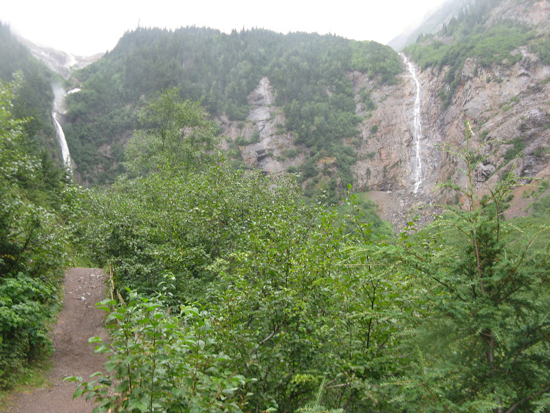 We stopped here to hike up to Twin Falls and Glacier Gulch. We went past the viewpoint for the falls, but the Glacier Trail looked like it might be a bit more than we were up for today.
  Right along here where we stopped was a plaque for a 40 year old man who died in an avalanche and a big, sturdy picnic table built into a corner of the trail. This is off the Lake Kathlyn (Loop) Road just a couple miles from Smithers. Smithers (5,217) is the largest town in Bulkey Valley and the site of 6,000 foot Hudson Bay Mountain, a popular ski area. The Visitor Center is behind a railcar and next to a big, old two-story museum. They have an Alpenhorn statue at the helm of main street and the downtown has a very alpine ski village feel to it.
  Besides the hike up to the falls, I guess the highlight for us was lunch at Tim Hortons. They are everywhere across Canada, like our Mc Donald's, I thought. Turns out they don't have burgers and fries. They have several kinds of soup, wraps, paninis and lots and lots of coffee drinks and pastries. It was okay, but I have heard Canadians down south say they like McDonalds better. I'm pretty sure that is because they have free coffee for seniors. When you are retired you have to make ends meet some way.
  This 60 foot long aluminum fly rod next to the Houston Visitor Center has a 21 inch flourescent fly. They have a nice little park there and a fountain with a sculpture of steelhead salmon jumping out of the water. Also the Hungry Hill Grizzly that was killing livestock is mounted in a glassed-in room out front. Across the street is another little park with an old church, log cabin and antique firefighting equipment. Two famous steelhead streams unite here, Morice and Bukley.
  We walked around town along the river and saw a few murals and this Spirit Bear statue in front of their new fitness center. If you look closely, you can see the spirit's face.
  Across the street from the Visitor Center is this tribute to a local boy who won the bull riding championship twice. It is carved out of wood. Established in early 1900's, Houston was the rail tie-cutting center during the building of the Grand Trunk Pacific Railway. Logging continued with the rapid growth of mills and planer mills in the 40s. Forest products are still the main industry along with mining, copper, silver, gold and molybdenum.
  You know you are getting back to farming country when you see a tractor crossing sign. We have seen nothing but moose, bear, bison, etc, signs the whole trip, especially moose. I guess there are about 150 each, moose and bison killed by cars every year up here. I sure wouldn't want to hit either one of those.
  We spent the night in Burns Lake at the free Lions Beach Park Campground, next to a beautiful lake with lily pads and ducks. The skateboarders and bikers were out here until well past dark doing fancy maneuvers. We did a little walk around town. They have a nice museum downtown next to the Visitor Center. Leaving Burns Lake there was a rest area with the Tintagel Cairn. Supposedly the central stone in this cairn once formed part of the Norman walls of Tintagel Castle, reputed birthplace of King Arthur. Unfortunately there was road construction right there, and they had the rest area closed.
  We stopped at the Frazer Lake Visitor Center which has a nice little museum. We grabbed a sandwich at Subway there and took another little side trip about 37 miles north to Fort St. James. It was established among the Carrier Indians in 1806 as a Northwest Company Trading Post. In 1821 it was taken over by the Hudson's Bay Company. It is fully restored to 1890s. The interesting part is that this trading post was in operation until 1952. The pioneering and homesteading up in this territory took place so much later than in our country, due to it's remoteness, extreme weather and harsh geographic conditions.
  They have interpreters in period costume explaining how the fort functioned. This building was a warehouse full of trade goods. The gentleman in here was explaining the different types of furs and how much they were worth. Kids got to pick a fur and take it over to the trading post to see what they could buy with it. There were stacks and stacks of bear hides on the floor and wolf, fox, coyote, beaver, mink, etc. hanging. The machine in the center is a pelt flattener. They would squeeze them flat and pack them into bundles for shipping.
 This is a view from the fort of 59 mile long Stuart Lake, the southernmost of a three-chain lake. There is a large settlement of Carrier Nation people here, originally called Dakleh. They had an interesting custom that widows carried their husband's ashes on their back and served their husband's family for a year after his death. Other tribes found this amusing or strange and referred to them as Carriers. It was considered a derogatory term, but over time has become their accepted name.
  This Junkers 34 (1/3 size replica) was the first northern "work horse" of the bush planes. Fort St. James was an important float plane base from the 1930s to 1970s. This monument to the planes and pilots is in a city park at the north end of town along Stuart Lake.
  We are getting back to farming and ranching country and the scenery is just beautiful. I'm sure we met at least 40 logging trucks in that short 37 mile drive, each way!
  This is a typical scene everywhere in this area.
  This unique little advertisement is at the corner where we turn back onto Yellowhead Highway near Vanderhoof.
  Just around the corner, there were about a dozen rows of these log piles. Someone told us there were a couple sawmills in Fort St. James, a couple in Vanderhoof and a dozen in Prince George. That's a lot of lumber!
  Just entering Vanderhoof is their museum complex with several old buildings. It looked very nice, but we are kind of museumed out on pioneers, natives, mining, lumber, etc. We spent the night at Riverside Park & Campground on the north end of town. We did a little walk around town and picked up a few groceries. A restaurant downtown has the Hobson History Museum, admission by donation. It supposedly tells the fascinating story of the lives of Richmond P. Hobson Sr. and Rich Hobson, Jr. and their wives. I've never heard of them, but will look them up later. Sr. was an Honor Medal Recipient, War Hero, Author, Congressman & Spokesman for many famous companies. Jr. was an author, rancher, subject of movie & TV series and Vanderhoof pioneer. Some of their famous friends were Mark Twain, Harry Houdini, Nikola Tesla & Buffalo Bill. Throughout this area there have been lots of BIG billboards warning against hitchhiking. Yellowhead Highway 16 is where there have been many young girls go missing over the past dozen years or so and they think there is a serial killer at work. In Vanderhoof there were pictures in all the business windows and some homes and big pictures plastered on the sides of buildings of a 20 year old girl missing since May, 2011 with a $100,000 reward. Very scary and
  sad!
sad! Mr. Pee Gee, or Mr. Pig, is at the old visitor center near the casino in Prince George. He was built for a float in the 1980s to honor the lumber industry. He was taken to several parades and became so popular, he became the city's mascot. This visitor center is now closed and there is a new one downtown.
 We drove around town a little and parked at Fort George Park on the Frazer River. We walked from there to Connaught Hill Park. At the base of the hill they have this heart-shaped flower bed and a sculpture and flags to honor workers killed on the job. We've never seen a monument to workers before. Perhaps the logging industry is more dangerous, higher death rate, than other industries.
 We hiked to the top of the hill for a view of the town. On the top of the hill is a one-way loop drive. As we were walking, someone was driving the wrong way and a couple guys coming the right way were waving at them. John told the person, "I think this is a one-way street". They backed up and turned around. The two guys drove by us and yelled out the window, "Must be from Mackensie River!" We just chuckled.
 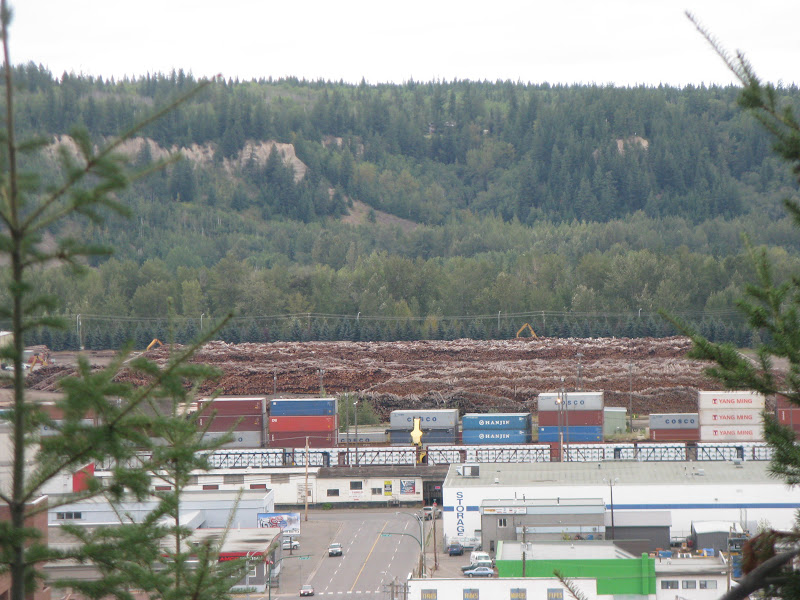 Some views of the city from the top of the hill. Another huge stack of logs at one of the sawmills. Just left of this photo were a half dozen or so mountains of wood chips.
Across the Frazer River is another sawmill in the distance with some mountains of woodchips showing above the trees. The first logs were cut here in 1807 to construct Fort George. In the 1940s Prince George became the center of the White Spruce industry in central B.C. The vast output of it's many mills earned it the title "Spruce Capitol of the World".
 We spent the night at Purdue Lake Provincial Park and went for a little hike through the woods and along the lake. Across the lake on the left side of the hill you can see the ski runs with the smoke from a campfire just below. Looks like someone built a little pen here to keep fish in or something.
  Stopping to admire the view and the reflections in the lake.
  On the road again, and following the pilot car again. Construction is a pain, but the roads sure are nice when they're done.
  Further down the road, we stopped to hike in the Ancient Forest, the furthest inland rainforest in the world. Some of the cedar trees here are over 1,000 years old, maybe as much as 2,000 years old.
  Cedar Circles are a mystery, but some scientists believe the parent tree may become injured and die leaving a circle of shoots that grow up from it's roots forming a circle of trees.
  T-I-M-B-E-R!!! Looks as if they could fall any second, but they have probably been leaning like that for centuries.
  McBride is in the Robson Valley by the Frazer River and was established in 1913 as a divisional point on the railroad. Their Visitor Center is in the historic train station at the end of Main Street. Their downtown sidewalks are painted blue for several blocks with the solar system laid out on them to scale and cut-out shapes of hockey players.
Also, all the fire hydrants around town are painted as characters. There is one in front of the train mural, too.
 Rearguard Falls Provincial Park. We stopped here for a short trek to see the falls.
  There was a memorial here to eight young men between the ages of 16 and 18 who lost their lives canoeing near here in 1974 in an unpassable canyon.
 Mount Terry Fox Rest Area is dedicated to a young man, who at the age of 18 lost his leg to cancer and undertook a run across Canada on an artificial limb to raise awareness and money for a cancer cure. He asked for a $1.00 donation from each Canadian ($24 million). He covered 3,000 miles training in the 15 months before he started. It was called the Marathon of Hope. He dipped his artificial leg in the Atlantic at St. John's, Newfoundland on April 12, 1980 and ran westward for the next 143 days covering on average every day, the equivalent of a marathon, 26 miles. On Sept. 1st near Thunder Bay, Ontario, well over half way home to B. C., he was forced to stop. The cancer had spread to his lungs and he died June 28, 1981 at age 22. The first Terry Fox Run attracted 300,000 participants and raised $3.5 million. In 1996 over a million people participated from Canada and around the world. By the 22nd annual run in 2002, the total raised was $360 million. Terry was posthumously inducted into the Canadian Sports Hall of Fame. The Sports Network named him "Athlete of the Decade" in a field that included Wayne Gretzky and Michael Jordan. The money now goes to the Terry Fox New Initiative Program of the National Cancer Institute of Canada. There is a hiking trail down to the river in the canyon.
  View of Mount Robson 12, 972 feet, highest peak in the Canadian Rockies. I read a sign that said British Columbia has 999 parks. I believe it. There seems to be a provincial park campground about every 10 or 20 miles and others in between for day use only. There are rivers, creeks, falls, lakes non-stop.
 A closer view right as we enter Mount Robson Provincial Park. You can just see the tips of the avalanche gates at the bottom of the picture. We see these quite frequently up here and some of the roads we have traveled on are not even kept open during the winter.
  There are several Mount Robson Provincial Park Campgrounds. We stayed at the Lucerne Lake Campground. I hiked down to the lake and took a few pictures just before sunset.
  The awe inspiring scenery is just never ending up here. You probably get used to it, if you live here. But I'm just like a kid in a candy store, with my head spinning in all directions, trying to decide which photo to snap next.
 More tomorrow.
Tarra

No comments:
Post a Comment