Thursday, Oct. 24th - Monday, Nov. 4th
 |
Heading west near the Montana/Idaho border. All the dying, yellow pine trees show the devastation the pine beetles are doing. Ironically, it looks like beautiful fall colors year around.  Views along the Columbia River about 100 miles east of Portland.  |

We camped three nights in front of David and Karen's house in Portland. Dorothy's doing great. I still can't beat her at cards!


After leaving Portland, we drove up through Washington a ways and crossed back over the Columbia River into Oregon here at Longview, Washington. Logging is big business around here.

Arriving in Astoria, we set up camp at Fort Stevens State Park, the largest campground west of the Mississippi with almost 600 campsites. But there are very few campers here this time of the year.

The first thing we did was hike the half-mile trail down to beach on Clatsop Spit to see the remains of the famous Peter Iredale shipwreck. One of the largest and finest sailing ships of her day, the four-masted British Barque became stranded here in 1906 and is one of the most photographed shipwrecks anywhere. John is walking next to the hull in the first picture. I am standing inside the hull in the next one.

John is walking along the length of the wreckage in this one. In the foreground you can see the base of one of the masts just sticking out of the sand.

Two poles sticking out at the far left by the setting sun mark the end of the wreckage.

Some of the gun batteries at Fort Stevens that was built during the Civil War, and named for Major General Isaac Ingalls Stevens (first Governor of Washington Territory) who seized the colors from a fallen flag bearer at the Battle of Chantilly in Virginia and was shot and killed in 1862. The fort was finished the day before the Confederacy surrendered at Appomattox Courthouse. During WWII the fort protected the mines in the Columbia River that were supposed to be stopping Japanese subs from coming up the river. It was once fired on by a Japanese sub.

Here's a little Bobcat wood chipper that was being used to clean up debris around the fort. That's job security for my little brothers who both work for Bobcat.

We went on a 13 mile bike ride to the fort and down to the South Jetty. We stopped for a little picnic lunch at this beach and watched the ships coming and going and the fisherman pulling up their baskets and checking to see what they had caught.

Pretty flowering shrubs along the ride that I have not yet identified. If anyone knows the name, please let me know.

Beautiful day and beautiful views when we arrived at the South Jetty.

We drove back up to the South Jetty another day when the winds were blowing about 30 mph and the waves were 10 feet high. Not a pleasant place to be that day at all!

We drove a few miles south to Sunset Beach that day, too.

You can drive right down to the beach, which John did, right up to the edge of where the waves were washing in. It was making me a little nervous.

From Cannon Beach, Tillamook Lighthouse is 1.2 miles out in the ocean on the far left. If you squint you can see it in this picture. It was a working lighthouse from 1880 to 1957, but is now a nature preserve with no public access, and the lighthouse is a columbarium. John's cousin's ashes are in the lighthouse.

This is a replica of the salt works camp at Seaside where the Lewis and Clark expedition stationed three men for six weeks boiling sea water down to extract salt. They boiled five kettles of water continuously and had 20 gal. of salt for their return trip home. Their winter camp at Fort Clatsop is about 12 miles northeast of here, about 5 miles from our campground. There is a Lewis and Clark National Park out here that includes about a dozen state parks and lots of the sites where they camped and trails they hiked and museums and interpretive centers. Everything you ever wanted to know about Lewis and Clark's Corp of Discovery and then some.

Astoria Column was built in 1926 by the Great Northern Railroad and Vincent Astor, great-grandson of John Jacob Astor, founder of Pacific Fur Company and Fort Astoria in 1811. Astor started in fur trading and eventually got into real estate in New York. When he died he was the richest man in the world, worth $20 to $30 million at the time. The column is 125 feet tall on top of 600 foot tall Coxcomb Hill with a panoramic view of the city, ocean, rivers and mountains for miles in all directions. The artwork, done by an Italian, is called sgraffito (skra-fe-to) and combines paint and plaster carvings to decorate the exterior with a frieze of 22 significant events depicting the discovery and settlement of the Columbia River until the arrival of the railroad.

This view is northeast toward the harbor where the canneries used to be, but now it's nice restaurants and shops and new homes. The big cargo ships, flying flags from many nations, anchor just offshore here while they are waiting to be loaded further upriver. They are importing cars, petroleum products and steel and exporting from Portland things like copper from Colorado and logs and grain from Longview, Washington. Places like Portland charge them fees like $1,000 a day, so they wait here because there is no charge. 250 to 300 ships pass Astoria every month.

This is looking northwest toward the mouth of the Columbia River and out to the Pacific Ocean. In the center of the picture is the Astoria Megler Bridge which connects Hwy. 101 from Oregon to Washington.

This is looking south toward Youngs River and Lewis and Clark River off Youngs Bay of the Columbia River.

This map shows where we were taking the pictures from the Astoria Column and the bridge across to Washington where we drove another day. Fort Stevens where we are camped is way up toward the end of the point by the mouth of the river where it flows into the ocean. Way out at the end is the South Jetty where we rode our bikes.

This map shows the Columbia River bar, known as the "Graveyard of the Pacific", where the silt and debris carried down the fast-flowing river encounter the Pacific tides depositing much sediment at the mouth forming sandbars that shift with the tides and currents, referred to as shoaling or shallowing, making it one of the most dangerous bar crossings in the world. Since 1792 when Captain Robert Gray (merchant marine and fur trader from Boston) made the first trip past the bar and up river in his ship, The Columbia Rediviva, approximately 2,000 vessels, including 200 large ships, have sunk with more that 700 lives lost. In 1977 the National Transportation Safety Board declared the bar a "specially hazardous area", the only river bar in the entire 88,533 miles of U.S coast line given this designation. The Columbia flows into the Pacific at 150 billion gallons a day and the ocean currents build underwater sandbars 5 to 10 feet high in a year. Millions a year are spent on dredging. The U.S. Army Corps of Engineers removes enough sand to fill 500,000 dump trucks, 5 to 6 million cu. yds. The bar is 600 yards wide, 5 miles long and 55 feet deep.

Astoria's answer to the street food cart or lunch cart, the lunch boat.

This swastika was one of the items in their local history museum. It was about 7" across. Toward the end of WWII, Norman Myer, who was deployed in Germany, was on top of a big rock next to a road when an open car drove by with several German officers inside. He dropped a hand grenade into the vehicle. When it exploded this Nazi symbol flew off and he brought it home as a souvenir. When the Japanese surrendered aboard the USS Missouri they turned over their Samurai swords and they became very popular souvenirs. Because of this there are now believed to be more of the swords in the U.S. than there are in Japan.

I toured the Flavel House, built in 1886 by Captain Flavel, a noted bar pilot, for his family. It is 11,600 sq. ft. and consists of two and a half stories, a full basement, a story and a half attic, a single story rear kitchen and a four story tower. It has 7,300 sq.ft. of finished living area. It has six fireplaces, 14' high ceilings, wall-to-wall carpet, gas lighting, indoor plumbing and central heating.

The property covered a full city block with gardens, a tennis court and the two and a half story carriage house in the far back corner. It was and still is the largest residential home in Astoria cost $36,000 to build. There were about 2,000 residences here in the 1880s and it was a rough and tumble town with all the usual vices of places like Deadwood and Dawson City. (Prostitution in the U.S. in 1858 was a $6.3 million industry, more than the shipping and brewing industries combined.) Astoria was the first permanent U.S. settlement west of the Rockies and the "Salmon Capitol of the World" in the 1880s with 55 canneries lining both sides of the river. Salting down fish to ship it had proved to be unreliable and a French scientist in 1809 had invented a method of canning to preserve food for Napoleon's soldiers, so the canneries sprang up everywhere. In 1878 Columbia River canneries produced 460,000 cases at $4.20 a case totaling $1.9 million (about $31 million today's dollars). Due to over fishing, mining, pollution, irrigation and dam construction, there are no major canning operations left here. There was a large Chinese population here and most of them worked in the canneries. Some of them could fillet a 40 pound salmon in 45 seconds and could do a ridiculous number like 800 or so in an 11 hour shift. Boy am I glad I didn't have that job! During WWII they were searching for a source of Vitamin A to help improve the night vision of the pilots. The discovery that shark's liver was a good source led to an entire fishery formed to catch soupfin and dogfish sharks off the Oregon coast. They paid $18 a pound for the livers. They cut the livers out and threw the rest of the fish away. In 1943 they produced 270,000 pounds of liver at a value of $5 million. In 1949 a synthetic source was made and that was the end of that industry.

The Columbia lightship tour is part of the Columbia River Maritime Museum. A lightship is essentially a small town anchored five miles out at sea. In winter rough seas can prevent any supplies from being delivered. The Columbia stored over 12 tons of food, 15,000 gal. of fresh water (Navy showers required, same as RV showers when we are in the boonies, quick rinse, soap and rinse), 47,000 gal. of fuel and a crew of 18. It was a "floating lighthouse" where needed, but not feasible to build one. It is equipped with powerful beacon lights, fog horns and radio beacon transmitters. There has been one in place since late 1800s and this last one was retired in 1979 when it was replace by an automated navigational buoy. On another note, towboats and tugboats are so powerful, that they can tow tens of thousands of tons at a time and push vessels 500 times their own weight.

The Peacock is a pilot boat. It's job is to transport the bar pilots to safely board all ships before they enter the bar, so they can skillfully guide them past jetties, over the sandbars and through shifting channels. All ships entering the bar are required to have a bar pilot aboard and to be able to understand English. They are the most highly trained pilots in the world. After passing the bar, a river pilot boards the ship at Astoria to guide it through the next 17 mile danger zone upriver to the sea buoy at Tongue Point. The long rock jetties were built between 1885 and 1895 to keep the Columbia River from moving around, to narrow the current to help flush out river sediment and to keep beach sand from clogging the river mouth. The South Jetty is 4 miles long, took ten years to build and was later extended 2.5 miles, the largest jetty in the world at the time. The North Jetty was built from 1914 to 1917 and is 2 miles long. Both combined took a total of 9 million tons of stones and created a 40' depth which was sufficient at the time. The larger cargo ships toady require a 54" depth creating a need for continuous dredging. The jetties up and down the coast have caused sand to pile up behind them moving the shore lines further out over time. The shoreline behind the South Jetty is a full mile further out than it was when Lewis and Clark arrived in 1805.

This small fishing boat was swept out to sea during the 2011 tsunami in Japan. Two years later after floating 5,000 miles it washed ashore at Cape Disappointment right across the river in Washington.

Scrimshaw cribbage boards carved on walrus tusks. Scrimshaw is an art practiced as early as 1631 by bored whalers. They would carve pictures and shapes on whale bones and walrus tusks. The art declined in the late 1800s, but has been making a comeback. In 1893 two public hangings were scheduled to take place on the courthouse lawn in Astoria and 1,000 invitations were issued. One man was hanged, but the other got a reprieve for five months. I wonder if the guests were disappointed.

Crossing the Astoria Megler Bridge over to the Long Beach Pennisula in Washington. It kind of looks like the road disappears into the river. The beach runs for 28 miles and you can drive on it. It is an official state highway, some of which runs along the paved Discovery Trail, which is a trail Clark took when exploring while Lewis and Clark were camped on the peninsula.

Fort Columbia State Park is our first stop after we crossed the river. Several of these renovated buildings can be rented as vacation houses. There are hiking trails and gun batteries.

A little further down the road is Port Ilwaca, a quaint fishing village.

As we were hiking up to see the North Head Lighthouse, we came upon the Coast Guard Air Station doing their regular training, raising and lowering guys into the rough seas below the cliffs. They are stationed out of Astoria and the buoy tenders work out of Tongue Point. The Motor Lifeboat Station is at Cape Disappointment right near here with volunteers since 1877 and a full-time crew since 1882. Since that time they have rescued an average of 600 people a year on the lower Columbia alone.

Brrr! They have to practice in rough seas.

North Head Lighthouse was built in 1898, 42 years after Cape Disappointment Lighthouse because ships coming from the north couldn't see it until they were already in dangerous waters..

There were three lighthouse keepers living here hauling buckets of oil down the long, narrow trail everyday to keep the light shining continuously. They kept gardens, chickens, etc. because they were so remote and had to be self sufficient.

This map shows some of the lighthouses along the Washington and Oregon coasts and the coastal areas we have been exploring.

This map shows just some of the shipwrecks around the Long Beach Peninsula and the mouth of the Columbia. There are supposedly Spanish shipwrecks here from as early as the 1500s and many Spanish gold doubloons yet to be found.

This is the Cape Disappointment Lighthouse and the Lewis and Clark Interpretive Center. They were the first Americans to reach the North Pacific over land, but Canadian explorer, Alexander MacKensie was the first in 1793.
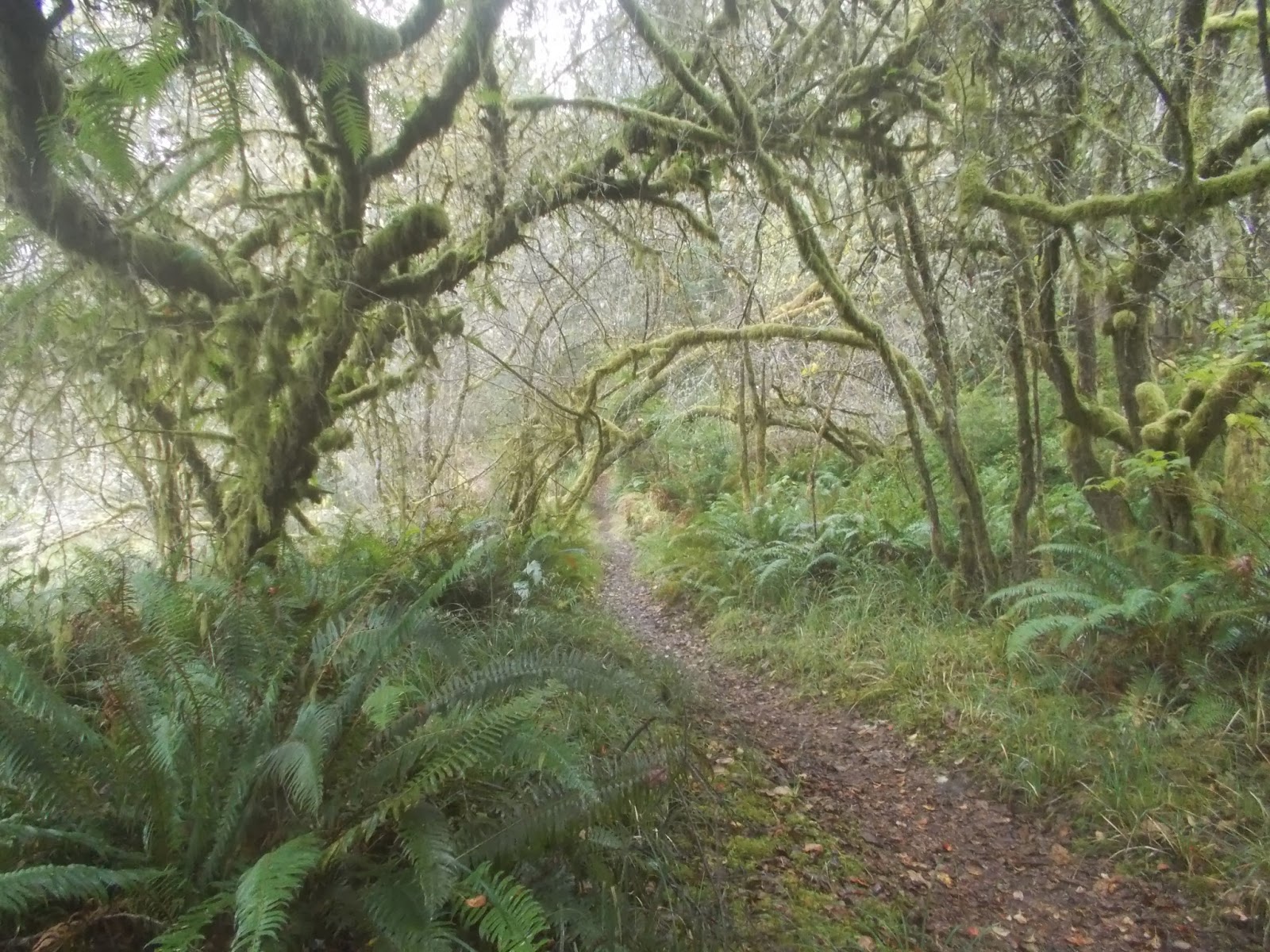
We did a three mile hike around Coffeebury Lake in Fort Stevens State Park near our campground. Notice the moss and ferns growing on the tree trunks and branches. It's so damp here. There was a light rain, then it sleeted, then the sun started to shine and it began pouring rain. Such weird weather, but it sure makes the plants grow!

As we were hiking down one of the trails, we came upon these. Does anyone know what they are?
Clark Gable started his acting career at the Astoria Theater in 1922. Cable TV owes its invention to L.E. Parsons who began experimenting with multiple cable hookups to antennas in Astoria during the 1940s. Ironically, the only place you'll see Clark Gable these days is on cable TV.
For my 60th birthday we dined at the Wet Dog Saloon/Astoria Brewing Company with a riverfront view, for the second time. I love eating out on the coast. They have my favorite foods fresh caught: fish and chips, shrimp, scallops, salmon, clam chowder, etc. It's awesome, and where else can you go to the restrooms and they are labeled Gulls and Buoys? We also ate at a Bosnian restaurant in Astoria called Drina Daisy that was really awesome. I had some kind of a cabbage roll thing with meat and risotto in it and it was so yummy and savory. John had a huge plate of sliced of roast lamb and it must of been the best meal he ever had in his life the way he carried on about it. We both highly recommend this place. I almost forgot, John turned 62 and is officially an old geezer now, so he was able to buy his lifetime National Park Pass for $10.00 while we were at Fort Clatsop. We will definitely get our moneys worth out of that!
We left here on Tuesday and drove down to Newport.
Sailing Steadily Southward,
Tarra

No comments:
Post a Comment